//English below//
//Tekst w języku polskim poniżej//
Vísindaráð almannavarna fundaði á fjarfundi í dag til að ræða jarðskjálftahrinuna á Reykjanesskaga. Fundinn sátu sérfræðingar frá Veðurstofu Íslands, Háskóla Íslands, ÍSOR, Umhverfisstofnun, Náttúrufræðistofnun Íslands og Orkuveitu Reykjavíkur auk fulltrúa frá Embætti landlæknis, Isavia-ANS og HS-Orku. Á fundinum var farið yfir mælingar og gögn sem hafa borist síðasta sólarhringinn.
Helstu niðurstöður fundarins:
- Kvikugangurinn heldur áfram að stækka og er mesta kvikuflæðið bundið við suðurenda hans. Á meðan kvika heldur áfram að flæða inn í ganginn þarf að reikna með að það geti gosið á svæðinu. Eftir því sem núverandi ástand stendur lengur aukast líkur á gosi. Afar litlar líkur eru á því að slíkt gos nái í byggð.
- Mikilvægt að fylgjast náið með virkninni í suðurhlíðum Fagradalsfjalls til að sjá hvort að þessi virkni er vísbending um að kvikugangurinn sé að stækka í suður.
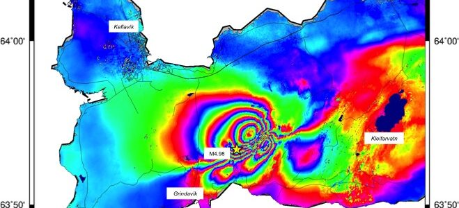
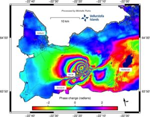
- Úrvinnsla á gervihnattamyndum sem bárust í morgun og nýjustu GPS mælingum, staðfesta að kvikusöfnun er áfram skorðuð við suðurenda kvikugangsins sem nær frá Keili að Fagradalsfjalli. Sá staður er áfram talinn vera líklegasti staðurinn komi til eldgoss.
- Ef kvikugangurinn heldur áfram að stækka og valda spennu á svæðinu, má eiga von á skjálftum sem finnast í byggð, sambærilegum þeim sem orðið hafa síðustu sólarhringana.
Nánar um niðurstöðu fundarins:
Snarpir jarðskjálftar mældust í suðurhlíðum Fagradalsfjalls í nótt og það sem af er degi og tengjast umbrotum syðst í kvikuganginum. Eins mældust nokkrir gikkskjálftar rétt norður af Grindavík en myndun kvikugangsins veldur spennubreytingum á stóru svæði m.a. vestur af Fagradalsfjalli. Skjálftavirknin í morgun hefur samanstaðið af minni skjálftum um 2 að stærð. Á meðan að það fyllist jafnt og þétt í kvikuganginn má áfram búast við kaflaskiptri og kviðóttri skjálftavirkni.
Úrvinnsla á gervihnattamyndum sem bárust í morgun og nýjustu GPS mælingum, staðfesta að kvikusöfnun er áfram skorðuð við suðurenda kvikugangsins sem nær frá Keili að Fagradalsfjalli. Sá staður er áfram talinn vera líklegasti staðurinn komi til eldgoss.
GPS mælingar benda til þess að hægt hafa örlítið á kvikuflæði, en óvissan í þeim mælingum er þó talsverð þar sem kvikan liggur mjög grunnt í jarðskorpunni (á um 1 km dýpi). Það er þó mat vísindaráðs að mikilvægt er að fylgjast náið með virkninni í suðurhlíðum Fagradalsfjalls til að sjá hvort að hún er vísbending um að kvikugangurinn sé að stækka til suðurs.
Kvika mun ekki komi upp með látum ef til eldgoss kemur
Eins og staðan er metin núna þá situr kvikan mjög grunnt, á 1-1.5 km dýpi. Það er mikilvægt að átta sig á því að ef kvika brýtur sér leið alla leið upp á yfirborðið þá má búast við að það gæti gerst án mikilli átaka eða skjálftavirkni. Dæmi um slíkt má sjá í gosinu sem hófst á Fimmvörðuhálsi árið 2010. Þá sáust ekki skýr merki um upphaf goss á mælitækjum Veðurstofunnar og voru það fréttir frá sjónarvottum sem staðfestu að kvika væri komin upp. Í þessu ljósi hefur Veðurstofan sett upp vefmyndavélar sem hægt er að notast við til að fylgjast með því ef kvika kemur upp.
English
News release from the Civil Protection and Emergency Management’s Science Board, 10 March 2021.
The Civil Protection and Emergency Management’s Science Board held an online meeting today in order to discuss the earthquake swarm in the Reykjanes Peninsula. The meeting was attended by specialists from the Icelandic Met Office, University of Iceland, Iceland Geosurvey (ÍSOR), the Environment Agency of Iceland, Icelandic Institute of Natural History, and Reykjavik Energy beside representatives from the Directorate of Health, Isavia-ANS and HS-Orka. Measuring and data that have been received the past 24 hours were reviewed at the meeting.
Main conclusions of the meeting
- Magma path continues to expand and the greatest magma flow is located at the southern end of it. While magma continues to flow into the path one has to reckon the likelihoods of an eruption in that area. The longer the present situation lasts the chances of an eruption increase. Very little chances are for that kind of eruption to threaten population.
- It is important to closely monitor the activity in the southern hills of Fagradalsfjall in order to see whether this activity is a signal that the magma path is expanding to the South.
- Interpretation of satellite images received this morning and the latest GPS measuring confirm that magma accumulation continues to be restricted at the southern end of the magma path that reaches from Keilir to Fagradalsfjall. That place continues to be considered the most likely place in case of an eruption.
- In case the magma path continues to expand and cause a tensity in the area, earthquakes can be expected that will be found in habituated areas, similar to the ones that have occurred the past few days.
Further on the conclusions of the meeting
Sharp earthquakes were detected in the southern hills of Fagradalsfjall last night and all day today and they are connected to changes in the southern-most part of the magma path. Also, a few tremors were detected just north of Grindavík, but the formation of the magma path causes changes in tensity in a big area, among others, west of Fagradalsfjall. The earthquake activity this morning has consisted of smaller quakes of about 2 in size. While the magma path fills up steadily a changeable and fitful seismic activity can continue to be expected. Interpretation of satellite images received this morning and the latest GPS measuring confirm that magma accumulation continues to be restricted at the southern end of the magma path that reaches from Keilir to Fagradalsfjall. That place continues to be considered the most likely place in case of an eruption.
GPS measures indicate that the magma flow has decreased a little bit, though the uncertainty in those measurements is considerable as the magma lies at a very shallow level in the earth’s crust (at the depth of approximately 1 km). However, it is the assessment of the Science Board that it is important to closely monitor the activity in the southern hills of Fagradalsfjall in order to see whether it is a signal that the magma path is expanding to the South.
Magma will not come up with great force in case of an eruption.
As the situation is assessed at present the magma lies at a very shallow level, at the depth of 1-1.5 km. It is important to realize that if magma breaks its way all the way to the surface, it can be expected that it could happen without much effort or seismic activity. Examples of such can be seen in the eruption that began in Fimmvörðuháls in 2010. Then no clear indication of the beginning of an eruption could be found in the measuring equipment of the Icelandic Met Office and it was news from witnesses that confirmed that magma had emerged. In this light the Icelandic Met Office has set up web cameras that can be utilized in order to monitor in case magma emerges.
Polski
Komunikat prasowy islandzkiej Rady Naukowej ds. Ochrony Ludności, 10 marca 2021 r.
Rada Naukowa ds. Ochrony Ludności spotkała się dziś na telekonferencji, aby omówić trzęsienie ziemi na półwyspie Reykjanes. W spotkaniu wzięli udział eksperci z Islandzkiego Urzędu Meteorologicznego, Uniwersytetu Islandzkiego, ÍSOR, Agencji Środowiska, Islandzkiego Instytutu Historii Naturalnej i Orkuveita Reykjavíkur, a także przedstawiciele Biura Dyrektora Medycznego ds. Zdrowia, Isavia-ANS i HS-Orka. Na spotkaniu omówiono pomiary i dane otrzymane w ciągu ostatnich 24 godzin
Główne wnioski ze spotkania:
- W dalszym ciągu powiększa się magmowy, a największe gromadzenie się magmy ma miejsce w jej południowym krańcu. Ponieważ magma nadal wpływa do tunelu, należy spodziewać się, że może na tym terenie dojść do erupcji. Na dzień dzisiejszy prawdopodobieństwo to zwiększa się. Jednak bardzo mało prawdopodobne jest, aby wypływ lawy dotarł do zabudowań.
- Ważne jest, aby uważnie monitorować aktywność na południowych zboczach wzniesienia Fagradalsfjall, aby sprawdzić, czy aktywność ta wskazuje, że tunel magmy rozszerza się na południe.
- Dane ze zdjęć satelitarnych otrzymanych dziś rano i najnowsze pomiary GPS potwierdzają, że gromadzenie się magmy jest nadal ograniczone do południowego krańca komory magmowej, która rozciąga się od Keilir do Fagradalsfjall. To miejsce jest nadal uważane za najbardziej prawdopodobnym miejscem w przypadku erupcji.
- Jeśli tunel magmy nadal będzie się powiększał i powodował napięcia w okolicy, można spodziewać się trzęsień ziemi, które odczuwalne są w obszarach zabudowanych, podobnych do tych, które miały miejsce w ciągu ostatnich 24 godzin.
Więcej o wyniku spotkania:
Silne trzęsienia ziemi zostały odnotowane na południowych stokach Fagradalsfjall zeszłej nocy oraz dzisiaj i są związane z ciśnieniem na południu komory magmowej. Kilka sejsmicznych trzęsień ziemi zostało również zmierzonych na północ od Grindavík, ale tworzenie się tunelu magmowego powoduje zmiany napięcia na dużym obszarze, np. na zachód od Fagradalsfjall. Dzisiejsza aktywność sejsmiczna składała się z mniejszych trzęsień ziemi o sile około 2. Ponieważ komora magmowa stopniowo się wypełnia, nadal można spodziewać się przerywanej i niepokojącej aktywności sejsmicznej.
Dane ze zdjęć satelitarnych otrzymanych dziś rano i najnowsze pomiary GPS potwierdzają, że gromadzenie magmy jest nadal ograniczone do południowego krańca komory magmowej, która rozciąga się od Keilir do Fagradalsfjall. To miejsce jest nadal uważane za najbardziej prawdopodobnym miejscem wystąpienia erupcji.
Pomiary GPS wskazują na niewielkie spowolnienie aktywności magmy, ale nie można zupełnie polegać na tych pomiarach, ponieważ magma leży bardzo płytko w skorupie ziemskiej (na głębokości około 1 km). W opinii Rady Naukowej ważne jest jednak ścisłe monitorowanie aktywności na południowych stokach Fagradalsfjall, aby sprawdzić, czy oznacza to, że komora magmowa rozszerza się na południe.
W przypadku erupcji nie będzie wybuchu lawy
W obecnej sytuacji magma jest bardzo płytko, na głębokości 1-1,5 km. Ważne jest, aby zdać sobie sprawę, że jeśli magma przedostanie się na powierzchnię, można się spodziewać, że może się to zdarzyć bez większych zakłóceń czy aktywności sejsmicznej. Przykładem tego jest erupcja, która rozpoczęła się w Fimmvörðuháls w 2010 roku. W tamtym czasie nie było wyraźnych oznak początku erupcji na urządzeniach pomiarowych Urzędu Meteorologicznego jedynie wpływały informacje od naocznych świadków, które potwierdziły, że wypłynęłą lawa. W tym świetle Biuro Meteorologiczne ustawiło kamery internetowe, które mogą być używane do monitorowania pojawienia się lawy.